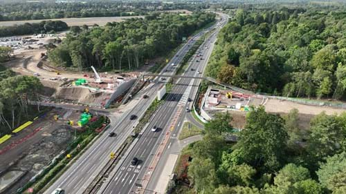
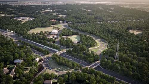
M25 junction 10
Restoring heathland and upgrading the junction with the A3 Wisley Interchange to reduce congestion, improve safety and create more reliable journeys.
Latest updates
-
15 April 2024
Announcing our second full weekend closure
We can confirm that the M25 will be shut between junctions 9 (A243 Leatherhead) and 10 (A3 Wisley) from 9pm Friday 10 May to 6am Monday 13 May 2024.
This full closure is needed to install a new bridge.
Only travel if necessary
We’re grateful to all drivers last time who avoided the closure and completed their journeys in other ways. We urge you to do the same again.
Diversion routes
A 19-mile diversion route will be in place which uses the A3 and the A240.
Please follow the diversion and don’t follow your SatNav.
Clockwise diversion for all but over-height vehicles:
- leave M25 at junction 8, A217 (Reigate)
- follow the A217 London, Sutton, (A240) Kingston
- after 3½ miles turn left onto the A240 Epsom, Kingston
- after 3 miles at the Esso roundabout, turn right onto the A24 (A240) Kingston
- continue for 3 miles and at the Tolworth interchange turn left onto the A3 Portsmouth, Guildford
- continue for 9½ miles to the M25 and re-join the motorway at junction 10
Anticlockwise diversion for all but over-height vehicles:
- leave M25 at junction 10 to join the A3 towards London
- after 9½ miles at the Tolworth interchange leave the A3 turning right onto the A240 Epsom, Reigate
- continue for 3 miles to the Esso roundabout and turn left onto the A240 Reigate
- continue for 3 miles then turn right onto the A217 Reigate, M25
- after 3½ miles turn left to re-join the M25 motorway at junction 8.
Drivers using the signed diversion route won’t be subject to any Ultra Low Emission Zone (ULEZ) charges that may usually apply. The Ultra Low Emission Zone will remain in force on all other routes in London across the weekend.
If you're driving an over-height vehicle you must follow a different diversion route to avoid a low bridge. This is your route:
Further closures
We intend to close the M25 for three more weekends this year.
There will be no weekend closures in June.
The remaining closures will take place between July and the end of 2024. We will be in a position to announce the date of the next closure as soon as the May closure is over.
-
28 March 2024
Our closures
There are no planned weekend closures over the Easter break, in April or the May Bank Holiday Weekends.
Our next large scale full weekend closures are currently scheduled for between May and the end of the year.
Scroll down to the 'Upcoming Closures' section for more details of over-night closures coming up immediately after Easter.
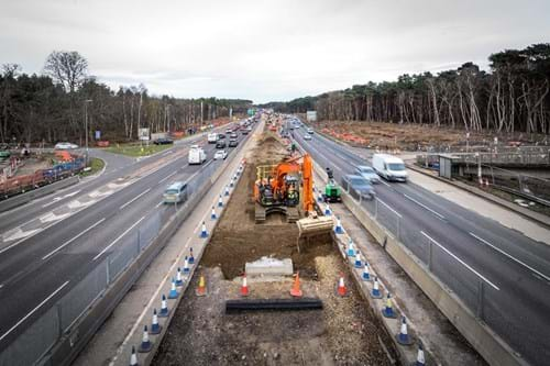
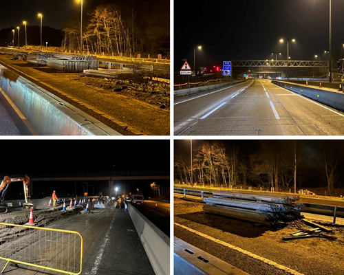
More milestones
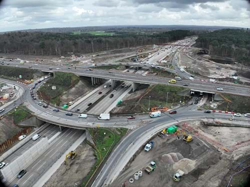
Progress continues on all parts of the project which you can see from this photo. Our ‘jet lanes’ (the lanes that will form our free flow left turns) are particularly taking shape.
Work will shortly resume on the A245 Byfleet Road between the Seven Hills Road junction and A3 Painshill interchange. Initially this will reduce the road to a single lane in each direction while we carry out some major drainage work in the central reservation. Work in the area is expected to last until the autumn and we must warn you there will be additional traffic congestion in the area as a result.
Road worker abuse
You may have seen us mentioned on BBC news again recently as part of a story about road worker abuse. Sadly, last year alone, over 600 incidents were recorded by our contractors, Balfour Beatty across the projects they work on. The BBC came to see us to talk about the scale of the problem.
Sadly, these are the facts:
- One in ten workers have been subjected to physical abuse in the past year.
- In 2021, within Balfour Beatty alone, two thirds of workers had been verbally abused by passing motorists.
- Worse still, 1 in 5 road workers have reported having missiles thrown at them in the past year.
Easter fun and reading time

Pics courtesy of St Mary's Primary School and Bob Holmes
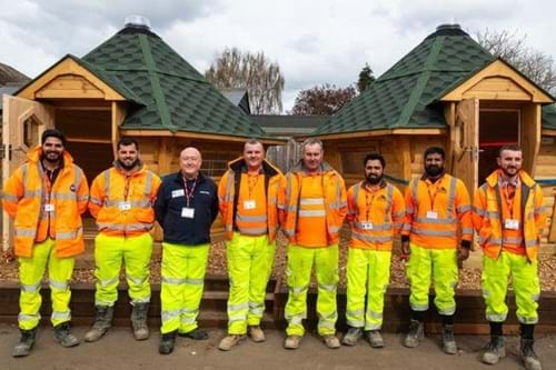
Away from the road, and on a more positive note, members of our Balfour Beatty team took a few hours off the road to help out at local primary school St. Mary’s in Byfleet this month. They made light work of installing two beautiful reading ‘pods’ that form a ‘Peaceful Place’ where children can read and learn away from the school building.
In the run up to Easter we've also been working with local charities on an Easter egg appeal and donated some 200 eggs to Guildford Action, Cobham Area Foodbank, and the YMCA Guildford.
This type of community work is really important to us and we look forward to doing more in the coming months.
In the meantime, wishing everyone a happy Easter. Don't forget to scroll down to the 'Upcoming Closures' section for more details of over-night closures coming up immediately after Easter.
-
17 March 2024
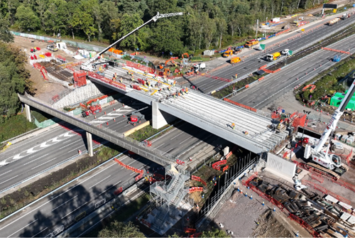
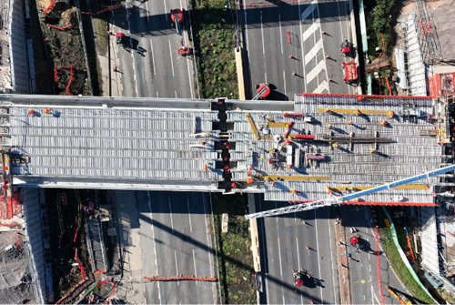
Bridge demolished and new gantry in place
On an eerily quiet M25 we finished our work eight hours ahead of schedule and were able to reopen the motorway at 10pm tonight (Sunday 17 March).
We know many people changed plans and amended their journeys and we'd like to thank everyone who had to make different arrangements due to our work.
We will announce the date of our next closure as soon as we can.
-
01 March 2024
More details about our M25 closure
Last weekend we closed the A3 for a full weekend and demolished two bridges.
Our next weekend closure will be for more demolition work, this time on the M25.
It means the M25 between junctions 10 and 11 will be closed in both directions from 9pm on Friday 15 to 6am Monday 18 March.
Diversion routes
The local diversion route below will be in place which is the same for both directions:
- Junction 10 - Junction 11: North bound A3 to Painshill Junction, A245 towards Woking, and then A320 to M25 Junction 11.
- Junction 11 - Junction 10: A320 south towards Woking, A245 towards Byfleet and Painshill junction, Southbound A3 to Junction 10.
Taking the M25 in the other direction to avoid our closure is also an option.
Either way, if you do travel, please leave a lot of extra time for your journey.
We carefully plan all our closures to limit disruption, but sometimes it's not possible to carry out all the work that's needed without a closure. We have planned all our closures to avoid holiday periods and key events in the area.
The work needs to be carried out now to continue the good progress on the delivery of the scheme which is due to open to traffic next summer.
-
31 January 2024
Announcing our next big closures
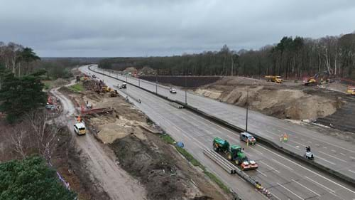
Last weekend we completed Sandpit Hill bridge, the third of our eight bridges.
It will be a few weeks before the bridge can be used as we still need to surface it, build the approach embankments and create the routes leading between Ockham Common, the bridge itself and Chatley Wood. Check back on this web page for when the bridge is available for use.
We're now moving to a phase of work that involves some significant closures of the A3 and the M25.
Our next closure is on:
Friday 15 March 9pm to Monday 18 March 6am the M25 between junction 10 and 11 in both directions, for demolition works and gantry installation.
-
24 January 2024
Completion of our third bridge
This weekend sees the completion of the third of our eight bridges, which is Sandpit Hill bridge that will link Painshill to Ockham Common. At 91 metres long, this will be the longest bridge we will install on the project, and it will cross the M25 to the east of junction 10.
Sandpit Hill bridge is for pedestrians, cyclists, and horse riders to safely travel between Ockham Common and Painshill. This is part of a new 5km route that will connect with many existing paths, tracks and bridleways that crisscross Wisley and Ockham Commons.
We’ve been building the bridge supports that will carry the new bridge across the M25, and we’re now ready to install the second piece of the platform to complete the installation.
The M25 will be closed anticlockwise between junction 10 at the Wisley interchange and Junction 9, and clockwise between the slip roads from 9pm Saturday 27 until 9am Sunday 28 January as we complete the installation of the footbridge at Sandpit Hill.
Diversionary routes are:
Vehicles over 14’6” on the M25 anticlockwise leave at junction 10 / A3 Wisley. Travel London bound on the A3 to the A245 Painshill, then A307 to A309, right into Hook Road then A243 to M25 junction 9 Leatherhead.
Vehicles under 14’6” on the M25 anticlockwise leave at junction 10 / A3 Wisley. Travel London bound on the A3 to the A240, then A217 to M25 junction 8 Reigate.
M25 clockwise between slip roads diversion: exit and re-enter junction 10 clockwise.
The A3 will remain open during these closures.
Throughout 2024 there will be other full weekend closures of the A3 and M25.
The first two closures are:
Friday 23 February 9pm to Monday 26 February 6am the A3 will be closed in both directions between Send and M25 Junction 10 Wisley Interchange, for demolition works.
Friday 15 March 9pm to Monday 18 March 6am the M25 between junction 10 and 11 in both directions, for demolition works and gantry installation.
-
09 January 2024
New Year, new bridge - Sandpit Hill footbridge
Our improvements on the M25 junction 10/A3 Wisley interchange project continues to make good progress.
As we continue with the construction of the new bridges, we are planning to install the third of our eight bridges, which is Sandpit Hill bridge that will link Painshill to Ockham Common. At 95 metres long, this will be the longest bridge we will install on the project, and it will cross the M25 to the east of junction 10.
Sandpit Hill bridge is just for pedestrians, cyclists, and horse riders to safely travel between Ockham Common and Painshill. This is part of a new 5km route that will connect with many existing paths, tracks and bridleways that crisscross Wisley and Ockham Commons.
We’ve been building the bridge supports that will carry the new bridge across the M25, and we’re now ready for the bridge to be installed.
To allow us to safely carry out the installation of the new bridge, we’ll need to close the M25 over two extended overnight closures. Scroll down to the 'Upcoming closures' section of of this page for the overnight closure details.
-
22 December 2023
Back on 3 January
The project is taking a break over the festive period.
Our work finishes today (Friday 22 December) and will restart on Wednesday 3 January.
During this time our traffic management will remain in place. Our CCTV team will be monitoring our work throughout the holiday and our traffic safety control officers will be on hand to help members of the travelling public if needed. Regular checks of our work sites will also be undertaken by our security officers during this time.
If you have any queries or concerns regarding the project whilst we are closed, please contact the National Highways, please contact the Customer Contact Centre by phone on 0300 123 5000 or email: info@nationalhighways.co.uk.
-
28 November 2023
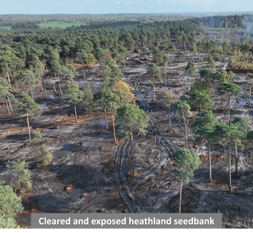
Heathland restoration at Ockham and Wisley Commons
We’ve completed most of the all-important heathland restoration work in several carefully selected areas, where heathland habitat once thrived. Since we started work at the beginning of September, we’ve been clearing non-native trees originally planted for timber production to restore 16 hectares of heathland.
Whilst the removal of trees may seem concerning at first, it is the first step to getting the heathland back to its natural state.
Heathland restoration isn’t as simple as planting or sowing seeds – we need to expose historical seed bank. We do this by removing trees, stumps, and the leafy top layer known as a humic layer. This then exposes the seed bank of the heath plants below.
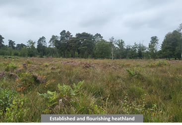
In as little as one year, heathland can begin to re-grow, and as time passes this rare habitat will flourish and support local wildlife. We understand the importance for people to enjoy the nature and landscape, and have retained a buffer of trees around the project.
We started the removal of trees and vegetation in September to avoid bird nesting season, which is usually between March and August.
We also avoid disturbing the ground whilst amphibians and reptiles are hibernating during the winter, generally starting at the beginning of November.
A team of ecologists put measures in place to ensure wildlife remained protected throughout the enhancement work.


We've also committed to manage and monitor the restored and enhanced heathland areas for up to 25 years while they establish. You can read more about this important part of the project in our Heathland FAQ's here.
-
16 October 2023
Wisley Lane bridge beams installed
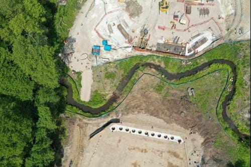
Good news – we’ve successfully installed all ten pre-cast concrete beams for our new bridge over the A3 at Wisley Lane.
Our teams worked around the clock all weekend while the road was closed to get everything in place and reach this important milestone. This meant manoeuvring a 750 tonne crane onto each carriageway in turn and lifting all of the 80 tonne beams into position.
In the future, this bridge will provide a new, safer route for walkers, cyclists, horse riders and drivers between the A3 Ockham Park junction and Wisley Lane.
Wisley Lane is the second of eight new bridges to have its beams installed in the last three months. The first one was down at Stratford Brook where this same route will travel across the smallest bridge on our scheme and meet up with the roundabout at Ockham Park.
We understand there’s never a good time to do roadworks and the impact this has on the people who live near or travel through our work.
Thank you for your patience over the last few days while we’ve been making our improvements.
-
05 October 2023
Bridges, beams and tunnels
Our new bridge at Wisley Lane is making great progress and is just one of eight being built as part of our improvements.
When complete, the Wisley Lane bridge will provide a new, safer route for walkers, cyclists, horse-riders and drivers between Wisley Lane and the A3 via Ockham Park roundabout.
Together, along with free-flowing left turns, extra lanes and a series of upgrades around the A245 Painshill, our scheme will create safer, smoother journeys for everyone travelling through the south east’s busiest interchange.
Down at Wisley, the beams for our bridge are almost ready to be lifted into position. We were due to install these in September, however this will now take place later this month.
Please check the upcoming closures section for the most up to date information about our full A3 weekend closure.
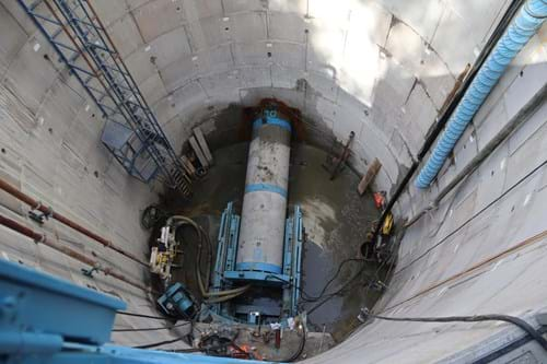
With so much going on above ground, you’d be forgiven for missing what’s been happening below ground.
Before we can widen the A3 on each side of the junction 10 roundabout, we need to divert a major gas main that runs alongside the A3. This is no mean feat – not to mention avoiding the array of electricity and water supplies that crisscross this area too.
Our tunnel boring machine, affectionately called Ada Florence, has completed her mission, having travelled 40 feet underground from one side of the A3 to the other.
This new tunnel will allow us to lay a brand-new gas pipeline underneath the road and eventually disconnect the old one when everything is up and running.
For all the latest updates, please subscribe to our newsletter or follow us on our Facebook page.
-
22 August 2023
Major heathland restoration gets underway
As well as making some significant safety improvements at junction 10 on the M25, we’re also restoring large areas of heathland across Wisley and Ockham commons.
- Heathland is one of the UK’s most threatened environments
- It is home to a number of rare invertebrates, reptiles, and bird species
- Heathland has declined by 85% over the last 200 years
Left on its own, heathland quickly grows into dense woodland and the animals and plants that depend on it disappear.
The heathland that once stood here is now largely dominated by Scots pine. Much of this was planted for timber production after the Second World War and has, over several years, become overcrowded, supressing the ancient heathland below.
What happens now?
From early September, we’ll be carrying out further tree and vegetation clearance in several areas across both commons which will allow the heathland to regenerate.
Although this may appear harsh, clearing areas of overgrown woodland will allow the heathland to regenerate and help bring back rare wildlife that inhabits it.
Find out more by coming along to our public information event:
Friday 1 September 2023 – 1.30pm to 4pm
Ockham Bites Car Park
Old Lane, Cobham KT11 1NAYou can also read more in our heathland restoration and woodland management factsheet and find answers to frequently asked questions.
-
04 July 2023
More bridges take shape
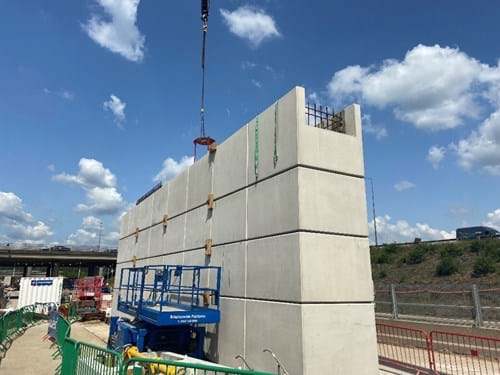
We’ve started to build two bridges on the M25 that will carry the new, wider junction 10 roundabout over the motorway and provide much needed capacity.
We’re using pre-cast concrete blocks which takes less time to build, uses less carbon and means we can keep the same number of lanes open for traffic.
The first bridge we started building at Wisley Lane is rapidly taking shape. We’ll need to close the A3 in both directions for a whole weekend this autumn to lift the bridge beams into position – please check back for more information.
We’ve also started to lay the foundations for the new bridge over Stratford Brook. This bridge will take a new road from Ockham Park onto Wisley Lane. The beams for this bridge will be the first to go in.
Read more in our latest newsletter
A245 improvements start soon
As part of our scheme, we’re making significant improvements around the A245 at Painshill to reduce congestion and ease the flow of traffic.
To help us get started, there will be full overnight closures on the A245 from Monday 10 July and a lane closure westbound from Monday 24 July between Painshill and Seven Hills Road.
We’ll start our work during the school holidays to keep disruption to a minimum, however the A245 and surrounding roads are expected to be busy, so please leave plenty of time and continue to take extra care.
Find out about the improvements we’re making in our dedicated factsheet.
-
13 June 2023
A245 improvements start soon
In July, we will be starting one of the next stages of our improvements project to deliver a package of road enhancements around the A245, Painshill roundabout and Seven Hills Road junction.
You may have seen us clearing vegetation and getting things ready to widen a section of the A245 in the direction of Seven Hills Road.
From Monday 10 July, there will be full overnight closures of the A245 and from Monday 24 July, there will be a permanent lane one closure westbound between Painshill and Seven Hills Road.
To find out more, come and visit one of our public information events:
Monday 19 June 2023
11am to 1pmTesco Brooklands, Barnes Wallis Dr, Weybridge KT13 0XF
Friday 30 June 2023
11.30am to 1.30pmSainsbury’s Cobham, Bridgeway, Cobham KT11 1HW
There’s more information about these improvements in our factsheetTraffic management work
You’ll start to notice some changes to our traffic management on the A3/M25 junction 10 as we move our work from the central reservation to the verge.
- A3 – Ockham Park to M25
From mid-June, there will be a dedicated lane for drivers heading towards RHS Wisley from the Ockham Park junction. In addition, all narrow lanes will move towards the central reservation.
Although the number of lanes will not change, lane 1, after RHS Wisley, will be used for M25 traffic towards Heathrow only. Lane 2 will be used for both M25 traffic towards Gatwick and A3 journeys towards London.
- A3 – southbound off-slip for M25
From late June, there will be some changes on the southbound approach to the M25 junction. Lane 1 will be used for M25 traffic towards Gatwick only. Lane 2 will be used for both M25 traffic towards Heathrow and A3 journeys south towards Guildford.
- M25 junction 10 roundabout
Once traffic management on the approaches have been installed and people are used to the new layout, the outer lane will be closed to tie in with the dedicated lanes.
Please do be mindful of this change and ensure you’re in the correct lanes as you approach the junction, to prevent any additional congestion.
-
26 May 2023
Changes to traffic management
We’ve made some changes to our traffic management so we can begin redirecting major services which run alongside the A3 such as gas and water.
We need to do this before we can widen the road and add extra lanes as part of our improvements.
Our safe working area between the M25 and Painshill has now moved to the verge and northbound A3 traffic is running closer to the central reservation.
The northbound exit slip at Painshill has been reduced to one lane to allow us to work safely in the verge.
Upcoming closures
We’ll need to carry out overnight closures on the A3 from Monday 5 June to move the narrow lanes between Ockham Park and the M25 closer to the central reservation.
Once this is in place, there will be a dedicated lane on the A3 northbound for traffic in and out of Wisley Lane and Gardens.
Please see full closure and diversion information below.
Wisley Lane bridge
We’ve almost finished building the central pier of the new Wisley Lane bridge and will shortly begin constructing the other piers on the verge where foundation work has already started.
Our piling rig has also been laying foundations on the M25 ready for two new gyratory bridges that will form the wider junction to ease congestion on the roundabout.
-
05 May 2023
New bridge takes shape
You may have noticed some new concrete blocks have appeared in the central reservation of the A3. These are hollow pre-made blocks that will be filled with concrete and form the centre support of the new Wisley Lane link bridge we’re starting to build.
This way of building the bridge means less disruption for road users as we can work in a smaller area and keep traffic flowing.
In the future, a new road from Ockham Park roundabout will go over the A3 to Wisley Lane, providing a much safer route for vehicles, walkers, cyclists, and horse riders to the RHS Gardens and Wisley village
What happens next?
Later this year, we will lift the new bridge deck beams into position and will need to close the A3. We’ll keep you updated on when we’re planning to do this.
Elsewhere, our pilling rig has been making its way around the central reservation of the M25, drilling foundations for the new junction 10 roundabout bridges which will be wider to increase capacity and improve journey times.
A245 and Painshill junction improvements
At Painshill, we’ve removed some more lighting columns in the central reservation so the A3 can be widened from three to four lanes between here and the M25.
We’ll soon start work to widen the A245 between the Painshill roundabout and the Seven Hills Road junction. Initially, there will be lane closures overnight while we carry out some surveys ahead of the main widening work which is due to start in July.
We’ll keep you updated as we get closer to these works.
-
04 April 2023
April update
Our improvements are well underway - read more in our April newsletter.
We’ve removed lighting columns and metal barriers in the central reservation on the A3 to make room to build the extra lanes as part of our scheme.
Foundation work has also started on the new Wisley Lane link bridge. Wisley Lane will no longer join directly onto the busy A3 and will massively improve safety at the junction.
Our scheme will see not one, not two, but eight new bridges, including the UK’s first ever heathland bridge.
Heathland restoration update
If you’ve passed through our work recently, you will have noticed a significant amount of tree clearance.
Although this might seem shocking at first, this is a natural part of resorting the ancient heathland that was once part of this landscape.
You can read more detail in our factsheets:
“Sett”-ling in…
We do everything we can to protect the environment and provide enhanced habitats for some of our more vulnerable species.
A replacement sett we built has been occupied!
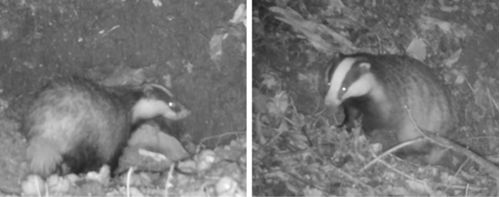
We’ve been monitoring our stripey-nosed friends very closely and our hidden cameras show a family of badgers are using the artificial sett.
As badgers are nocturnal and quite weary of humans, we don’t know how many exactly have re-located, but we do know they have and are settling in rather nicely.
Read more in our Habitat factsheet.
-
13 March 2023
Extended hours closures (M25) – March/April 2023
We need to carry out some overnight closures of the M25 this month to continue with our improvements.
Our normal overnight closure times are usually between 9pm and 6am, however we will need to do some extended overnight closures finishing later at 8am instead. This is because we need more time to safely remove the gantries and make room for the new bridges as part of our scheme.
We'll also be finishing some resurfacing in the Burpham area and will need to close the A3 between the Burntcommon entry slip and Dennis Interchange.
Closure information
- Friday 17 March – 9pm to 6am
The M25 will be closed anticlockwise overnight between junctions 11 for Chertsey and junction 10 for the A3. - Extended closure: 9pm Saturday 18 to 8am Sunday 19 March
The M25 will be closed anti-clockwise overnight between junctions 11 and 10. - Monday 20 to Friday 24 March – 9pm to 6am
The A3 will be closed southbound from the A247 Burntcommon entry slip to A25 Dennis Interchange for resurfacing. For more details, please see our maintenance page. - Monday 27 to Friday 31 March – 9pm to 6am
The M25 will be closed clockwise overnight between junctions 9 for Leatherhead and junction 10. - Extended closure: 9pm Saturday 1 to 8am Sunday 2 April
The M25 will be closed clockwise overnight between junctions 9 and 10.
Diversion information
- M25 anti-clockwise
Drivers will be diverted from junction 11 along the A320 and A245 through Byfleet to join the A3 at Painshill - view diversion route map - M25 clockwise
All vehicles under 14’6” will be diverted from the M25 at junction 8 (Reigate) along the A217, A240 and join the A3 at Tolworth. Vehicles over 14’6” will be diverted from the M25 at junction 9 (Leatherhead) along the A243, A309 and A307 through Esher and A245 to join the A3 at Painshill - view diversion route map - A3 southbound
Drivers travelling from London towards Guildford will be diverted from the Ockham roundabout and follow the B2215 and A247 towards West Clandon and use A246 and A31 to join the A3 at Down Lane - view diversion route map
- Friday 17 March – 9pm to 6am
-
21 February 2023
Central reservation work and upcoming closures
We’ve finished putting in narrow lanes and a reduced speed limit on the A3 and have started to remove the lighting columns and metal barriers in the central reservation.
We’ve also started putting in narrow lanes and a reduced speed limit on the M25 in both directions underneath the junction and will be starting some work on the slip roads so we can continue with our improvements.
Slip road and roundabout closures – March 2023
Our overnight closures will usually start from 9pm and finish by 6am but this can change depending on the volume of traffic and when we can close the road safely.
On Thursday 2, Friday 3 and Monday 6 March, there will be NO overnight access from the
- M25 anti-clockwise to A3 northbound or southbound
- A3 southbound to M25 clockwise or anti-clockwise
Drivers travelling from Heathrow wishing to join the A3 southbound will continue their journey and return via Leatherhead. Drivers wishing to join the A3 northbound will return via Leatherhead and Ockham Interchange.
Drivers travelling from London wishing to join the M25 towards Heathrow will continue their journey and return via Ockham Interchange. Drivers wishing to join the M25 towards Gatwick will return via Ockham Interchange and Chertsey.
Drivers travelling from Gatwick wishing to join the A3 northbound will be diverted via Ockham and return.
Drivers travelling from Guildford wishing to join the M25 anti-clockwise will be diverted via Chertsey and return.
On Tuesday 7, Wednesday 8 and Thursday 9 March, there will be NO overnight access from the
- M25 clockwise to A3 northbound or southbound
- A3 northbound to M25 clockwise or anti-clockwise
Drivers travelling from Gatwick wishing to join the A3 northbound will continue their journey and return via Chertsey. Drivers wishing to join the A3 southbound will continue their journey via Chertsey and Painshill.
Drivers travelling from Guildford wishing to join the M25 towards Gatwick will continue their journey and return via Painshill. Drivers wishing to join the M25 towards Heathrow will return via Painshill and Leatherhead.
Drivers travelling from Esher wishing to join the M25 clockwise will be diverted via Leatherhead and return.
Drivers travelling from Heathrow wishing to join the A3 southbound will be diverted via Painshill and return.
The M25 will also be reduced to one lane clockwise as it passes underneath the junction.
Why are narrow lanes and speed restrictions needed?
Our traffic management helps us keep the same number of lanes open and traffic flowing. We put a reduced speed limit in place to keep our workforce and the travelling public safe.
To plan your journey, visit Traffic England
For more information about the scheme, please visit our information portal
-
01 February 2023
Overnight closures – January/February 2023
We’re putting in narrow lanes and a reduced speed limit on the A3 and M25 at junction 10 to create a safe working space for our team and keep traffic moving as we start our improvements.
Our overnight closures will usually start from 9pm and finish by 6am but this can change depending on the volume of traffic and when we can close the road safely.
M25 clockwise
The M25 will be closed clockwise overnight between junction 9 for Leatherhead and junction 11 for Chertsey between:
- Tuesday 7 to Friday 10 February
- Monday 13 to Friday 17 February*
Drivers will be diverted off the M25 at junction 8 and take the A217 and A240 to join the A3 southbound at Tolworth. Leave the A3 at Painshill and follow A245 to Six Cross roundabout and use A320 to join the M25 at junction 11.
M25 anti-clockwise
The M25 will be closed anti-clockwise overnight between junction 11 for Chertsey and junction 9 for Leatherhead between:
- Monday 20 to Friday 24 February*
Drivers will diverted from junction 11 along the A320 and A245 through Byfleet to join the A3 northbound at Painshill. Leave the A3 at Tolworth and follow the A240 and A217 to join the M25 at junction 8 for Reigate.
Additional A3 works
*At these times, we’ll also be doing some additional work on the A3 overnight in both directions as they cross over the M25 at junction 10.
Drivers will be diverted off the A3 onto the M25 junction roundabout and join again to continue their journey.
NEW: We'll also be finishing some resurfacing further down the A3 at Burntcommon from Monday 13 to Friday 17 February 2023.
Drivers heading southbound from this point will then be diverted from Ockham via B2215/A247 towards West Clandon and A25/A246 through Guildford to reach the A31 Farnham Road to join the A3 at Down Lane. Drivers will still be able to join the A3 at the A25 Dennis Interchange and travel south.
For full details, please visit our south east maintenance page.
Our diversion routes are designed to suit all types of vehicles. If you use a Satnav when following our diversion, there is a risk it could direct you down an unsuitable road or try to direct you back onto our network when it is closed.
Plan your journey, even if it’s a regular trip. You can do this by checking our Daily Closure Report or visiting our Travel Updates page.
-
12 December 2022
Start of work
We’re about to start our work to improve M25 junction 10/A3 Wisley interchange.
You’ll see us removing trees and other vegetation first of all. Find out more about why we’re doing this by reading our Heathland Restoration and Woodland Management factsheet. Please also read our your questions answered factsheet – it may answer any questions you have.
Introduction of narrow lanes on the A3 and footpath diversions
We’ll be introducing temporary changes to the road layout on the A3 and M25 junction 10 slips to help keep traffic flowing smoothly and create a safe working area for our team. We’ll be putting narrow lanes in place on the A3 and reducing the speed limit to 50 mph – the narrow lanes and lower speed limit means we can keep three lanes open.
We’ll also be working around the common areas and at times you may find that we have footpath diversion routes in place.
We’ll usually work between 7:30am and 6pm Mondays to Fridays, and 8am to 7pm on Saturdays, so there may be times when you won’t see anyone on site. We’ll also need to carry out some work overnight using road closures. You can find more information about our planned closures over the next few months below. We apologise for any inconvenience this may cause to your journey.
Our improvements will be completed by summer 2025, and you can find out more about what is planned when on our project timeline.
Planned closures – December 2022
Our planned overnight closures for December are below. These closures will allow us to carry out some survey works in the central reservation and verge areas along the A3.
To help reduce the impact to road users and local community during Christmas and New Year period, we’ll be carrying out our closures to set up the temporary changes to the road layout on the A3 and M25 in January 2023. We will share more details about these closures and changes shortly.
Date and times
Closure
Diversion
Monday 12 to Wednesday 14 December
10.30pm to 05.30amA3 southbound from M25 junction 10 to Ockham roundabout
Motorway traffic will be diverted onto the M25 anticlockwise to M25 J9 where they will exit and take the A24 South towards Leatherhead/Dorking and then via the A246 and A247 to Clandon Cross roads.
Non-motorway traffic will be diverted via the Painshill junction, A245 towards Cobham, A397 towards Esher. The A309 towards A3 Hook and A234 towards M25 junction 9, A24 South towards Leatherhead/Dorking and then via the A246 and A247 to Clandon Cross roads.
Thursday 15 December
10.30pm to 05.30amFriday 16 December
11pm to 6amA3 southbound from Painshill junction to M25 junction 10
Motorway traffic will leave the A3 via Painshill and follow the A24 towards Cobham where they will take the A307 at Between Streets towards Esher and the A309 towards the A3 Hook. From here the A243 will continue to the M25 junction 9.
Non-motorway traffic diversion will follow the same route as above but will continue on the A24 South towards Leatherhead/Dorking and then take the A246 South to the Clandon Cross Roads where they will turn right to the A247 and to the A3.
We'll be keeping this webpage updated with the latest information, and you can register to get our email newsletters using the 'Sign up for updates' button on this page.
If you have any queries, you can contact the team on M25j10@nationalhighways.co.uk at any time during the scheme.
-
21 July 2022
Preparation work and the opportunity to meet the team
While our main work will start in mid-September and be completed by Summer 2025, we'll be carrying out some work to help prepare for construction from mid-June. This preparation work will reduce the risk of any delays, and includes:
- Construction of our site compound at Nutberry Fruit Farm in June, and our compound at Wisley Airfield in July
- Trial and bore hole surveys to confirm the locations of existing utilities and reduce the risk of finding any surprises. This work will be carried out at night and, in some locations, we will need to close footpath or road lanes.
- Utility diversions at both Ockham interchange and Painshill junction, these will require traffic management to be put into place
- Preparation work on Elm Lane
- Installation of CCTV
Want to know more about the scheme?
Thank you to everyone who attended one of our recent face-to-face or virtual information events.
We'll be keeping this webpage updated with the latest information, and you can register to get our email newsletters using the 'Sign up for updates' button on this page.
If you have any queries, you can contact the team on M25j10@nationalhighways.co.uk at any time during the scheme.
-
12 May 2022
Development Consent Order given the green light
Today we welcomed the Secretary of State for Transport decision to grant us a Development Consent Order, which allows us to proceed with our project to improve the M25 junction 10/A3 Wisley interchange.
This junction is one of the busiest on our network, with almost 300,000 journeys every day. Due to the volume of traffic and the resulting queues, the junction and the surrounding roads have a high number of incidents. Our proposals will deliver much needed additional capacity, better connectivity for people and businesses, and safer journeys for everyone.
This vital work will generate more than 400 jobs, including around 20 apprenticeships and graduate jobs, and deliver an environmental legacy that will restore rare heathland in Ockham and Wisley Commons for years to come.
You can view the decision documents the Planning Inspectorate website.
Keeping you informed
We plan to start work in autumn 2022. To make sure you know what’s coming and to keep everyone up to date we will:
- issue regular project newsletters – you can join the mailing list by signing up on this page
- run online briefings in June to provide the opportunity to ask the team any questions, as well as providing information about our online portal
- organise face-to-face events using our engagement van at local venues. These will provide information about the scheme and allow us to answer any questions you and others may have. We will provide you with more details of these on this page soon.
-
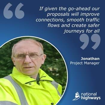
03 May 2022
May update
We’re due to be hearing from the Secretary of State for Transport by 12 May, on whether we can continue with our proposals to improve M25 junction 10. Here is an overview from Jonathan, our Project Manager, about the Development Consent Order (DCO) decision process and what to expect following a decision.
Why is the Development Consent Order process in place for this scheme?
The M25 junction 10 project was considered by the Government to be so big and nationally important that it met the criteria of being a Nationally Significant Infrastructure Project (NSIP), as defined in the Planning Act 2008. This means that permission to build it would need to be given at a national level through the Development Consent Order process. You can find out more about this process by watching this short animation.
What are the different decision scenarios that the Secretary of State for Transport could announce?
There are a number of possible scenarios. The DCO could be granted, and one of our first steps would be to read the Examining Authority’s report in full to understand any recommendations that have been included. The DCO decision could also be deferred again, or it could be rejected entirely.
What can’t happen is that we are granted a DCO covering only parts of the works. The package of work is a complete entity, referred to in the DCO as the “authorised development”. If the DCO is granted, we expect that there will be a period of approximately three weeks between it being announced and the powers within it coming into force.
If the decision is approved where I will be able to find out more information?
You will be able to find out more information here on our dedicated webpage, where you can also sign up for our updates and newsletters. We we’ll also be running a series of public information events where you will be able to come meet the team and ask questions. More details will be shared about these events should our proposals receive a positive decision.
Why does M25 Junction 10/A3 Wisley need improving?
Junction 10 is one of the busiest sections of the M25, with almost 300,000 vehicles travelling through it every day. Due to the volume of traffic and the resulting queues, this area of our network has a very poor safety record and holds one of the highest collision rates across the National Highways network. Our proposals will reduce delays, improve connections, smooth traffic flow and create safer journeys for all. The scheme will also involve some of the most extensive environmental mitigation ever carried out by National Highways.
Supporting the local community
While we wait for a decision we have been continuing to engage with stakeholders, supporting our local community, and looking at opportunities to help prepare us to start works, should we get approval.
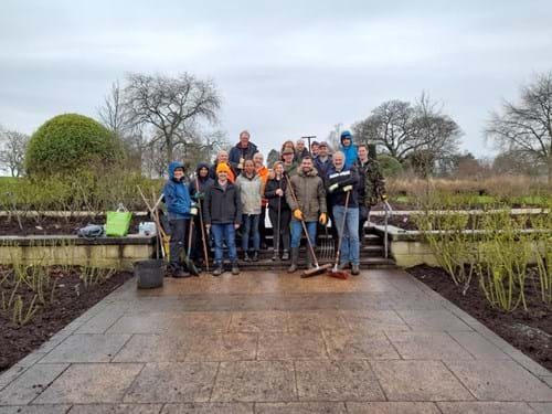
Last month our project team recently volunteered alongside the team at RHS Wisley Gardens. Our team spent the day working in the Bowes Lyon Rose Garden, helping to get the area ready for summer. This involved laying down a mulch which will help the soil retain moisture in the summer and prevent weeds from growing. We would like to say a big thank you to the RHS for welcoming us into their gardens. The Royal Horticultural Society are a charity who aim to inspire a passion for gardening and growing plants, along with promoting the value of gardens and the vital role for people and the planet that plants play.
We have been busy collecting essential items to support the North Guildford foodbank, along with volunteering at the food bank itself sorting food parcels. We also took the opportunity to get involved in the recent Great British Spring Clean initiative by completing a litter pick around our scheme. The campaign by Keep Britain Tidy, looks to encourage everyone to take part in litter picking events, and think about the risk that litter causes to local wildlife, and to the workers out collecting it. In 2021, 30,000 bags of litter were collected from the M25 network area, so its important issue for us and we can all help keep our roads safe and tidy.
-
28 February 2022
February update
In December, the Secretary of State for Transport wrote to us on our proposals to improve the M25 junction 10/A3 Wisley interchange. In his consultation letter, the Secretary of State asked for further information about our replacement land proposals, and our environmental data. You can read our full response here. We look forward to hearing from the Secretary of State for Transport in May on whether we can continue with our proposals. To make sure we’re in the best position to get going with delivering our scheme, should we get the go-ahead, we have been using the last few months to update our environmental surveys, engage with our stakeholders and volunteer in the local community.
We have been repeating our bat and badger surveys in the local area to make sure our information is up to date. For the bat surveys our ecologists have been looking at local trees to see if they have signs, or the potential, to support hibernation or maternity roosts – for several weeks in the summer female bats gather in a roost to have their babies, and we need to ensure our work does not disturb either of these roosts. The badger surveys involved walking around areas where badger setts have previously been identified to look for any signs of new setts.
Our programme of work takes into account the seasonal activity of all protected species and includes extensive ecological mitigation measures. These measures include restoring rare heathland habitat, enhancing existing woodlands, creating new woodlands and parkland. These improvements will benefit a host of species including invertebrates, birds, reptiles, small mammals (including bats) and larger mammals such as badgers, and even us humans who will be able to access much of this new and diverse habitat.
You can read more about the environmental surveys and how we have been visiting other major National Highways schemes in our latest newsletter.
Volunteering day at RHS Wisley Gardens
Our project team recently volunteered alongside the team at RHS Wisley Gardens. Our team spent the day working in the Bowes Lyon Rose Garden, helping to get the area ready for summer. This involved laying down a mulch which will help the soil retain moisture in the summer and prevent weeds from growing.
We would like to say a big thank you to the RHS for welcoming us into their gardens. The Royal Horticultural Society are a charity who aim to inspire a passion for gardening and growing plants, along with promoting the value of gardens and the vital role for people and the planet that plants play.
-
17 December 2021
December update
We are continuing to engage with stakeholders and our local community, along with giving support to other schemes that have recently started works, while we wait for a decision on whether we can continue with our proposals to improve the M25 junction 10/A3 Wisley interchange.
Our project team have recently volunteered with a local foodbank and spent time with students from East Surrey College. The students are all interested in careers in construction and engineering and we talked to them about the jobs that we do, our careers and future employment opportunities. The College offers full-time and part-time courses as well as apprenticeships, university level and new level 3 T level qualifications for the construction and engineering sector. Level 3 business student, Elizabeth, said “It was cool to hear about how the digital sector use drones across the country to capture aerial images and videos of the work happening on site.”
We also recently asked for your feedback on our newsletters and what else you would like to hear about. You can read more about the feedback that was shared with us, our visit to the College and some tips for travelling safely in winter in our latest newsletter. Sign up to our mailing list and you can receive our newsletters straight to your inbox.
If approved our proposals will improve connections, smooth traffic flows and create safer journeys for all. The deadline for our scheme decision is 12 May 2022 and we will keep this webpage updated with any latest updates.
-
21 October 2021
Decision deadline extended to May 2022
The Secretary of State for Transport has asked for more time to make a final decision on whether we can continue with our proposals to improve the M25 junction 10/A3 Wisley interchange.
In his statement, the Secretary of State sets out he is extending the deadline to 12 May 2022 to allow for further consideration of environmental matters.
We’re committed to delivering the improvements at M25 junction 10 and remain confident that our proposals will deliver much needed additional capacity, with better connectivity for people and business, and safer journeys for everyone. This junction is one of the busiest on our network, with almost 300,000 journeys every day.
Thank you to everyone for their engagement and contribution in the development of the scheme to date. We will continue to work with the Planning Inspectorate, local stakeholders and local authorities until the Secretary of State makes his decision.
Further information regarding the extension and any additional consultations will be posted on the Planning Inspectorate’s website.
-
26 July 2021
Project update – July 2021
In May, the Secretary of State for Transport has asked for more time to make a final decision on whether we can continue with our proposals to improve the M25 junction 10/A3 Wisley interchange. In his statement, the Secretary of State set out the 6-month extension and provided the new deadline of 12 November 2021. Details of the additional information requested by the Secretary of State can be viewed the Planning Inspectorate’s website.
We remain confident that our proposals will deliver much needed additional capacity, with better connectivity for people and business, and safer journeys for everyone. You can now visit our virtual information portal that outlines our proposals and the safety and environmental benefits they would bring. Just click on the ‘view the portal’ option at the top of this page. We would be interested to hear your feedback on the portal, and you can share your thoughts with us using the get in touch section on the portal or by email on M25j10@highwaysengland.co.uk.
Since the announcement, we’ve spent the time understanding what this extension means for our plans. As part of this we’ve looked at what we can do to get ready if our proposals were to be approved. One of these is to apply for planning permission for our main site compound. The permission will allow us to build our offices during warmer months and to ensure we are ready to deliver the wider scheme programme. The application will be reviewed by Guildford Borough Council and we expect to hear back over the next couple of months.
-
12 May 2021
Decision deadline extended to November 2021
The Secretary of State for Transport has asked for more time to make a final decision on whether we can continue with our proposals to improve the M25 junction 10/A3 Wisley interchange.
In his statement, the Secretary of State sets out the 6-month extension is to allow for further consideration of environmental matters, and provides the new deadline of 12 November 2021.
Thank you to everyone for their engagement and contribution in the development of the scheme to date. Further information regarding the extension and any additional consultations will be posted on the Planning Inspectorate’s website.
We remain confident that our proposals will deliver much needed additional capacity, with better connectivity for people and business, and safer journeys for everyone. This junction is one of the busiest on our network, with almost 300,000 journeys every day. Due to the volume of traffic and the resulting queues, the junction and the surrounding roads have a high number of incidents.
-
04 May 2021
Decision update
In January 2021, the Secretary of State for Transport delayed his final decision on our proposals to improve the M25 junction 10/A3 Wisley interchange to 12 May 2021.
This four-month extension is to allow the Secretary of State to understand more detail in certain areas of our application. You can view the written statement about the extension on the Planning Inspectorate’s website.
Thank you to everyone who has got involved in the development of the scheme so far. More information about the scheme, along with the decision when it is announced, can be viewed on the Planning Inspectorate’s website.
Project information
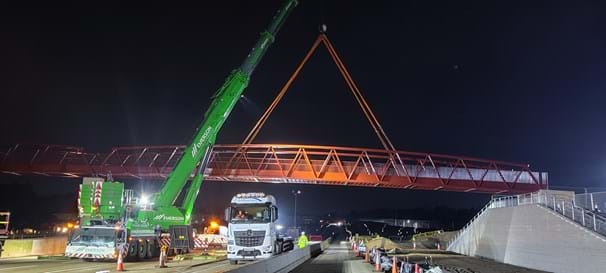
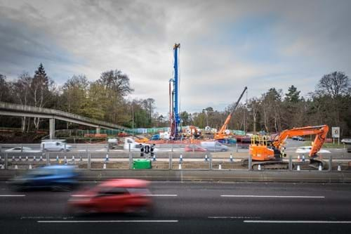
Clearmount Bridge demolition - March 2024
This video of the Clearmount Bridge demolition shows the scale of the work we are doing and why we need full closures to perform it safely.
Manage your cookie preferences to view the content on this page
General information
- We will announce our next weekend closure of the A3 and the M25 shortly
- Our overnight closures are usually between 9pm and 6am - unless otherwise stated.
- The A245 has one lane closed westbound between Painshill and Seven Hills Road.
- For information on footpath and bridleway closures, visit our pedestrian, cycling and horse-riding factsheet.
- For closure information across our network, visit our travel updates webpage
Week commencing Monday 22 April
From Monday 22 April to Friday 26 April between 10pm and 5.30am we will be closing the A245 in both directions between the Sainsbury roundabout at Cobham and the Seven Hills Road Junction. This will include a full closure of the Painshill roundabout and A3 exit slip roads both north and south Bound.
The diversions will be:
A3 North bound exit slip road will be via the A3 north to the A244 Esher then left to the A244 Esher. At Esher the diversion will split and traffic for the A245 Byfleet will divert via the A244 to the A317 Queens Road to the B365 Seven Hills Road ending at the junction with the A245 and traffic for Cobham will be via the A307 to Cobham junction with the A245.
A3 South bound diversion will be via the A3 South bound to the M25 J10 and return via the A3 north bound following the diversion above.
Diversion for traffic at Cobham will be via the A307 to Esher and then split - with A3 traffic tacking the A244 east to the A3 where they can join either south or north bound – traffic for Byfleet will use the A244 to the A317 Queens Road to the B365 Seven Hills Road.
Diversion for the A245 east will be via the B365 Seven Hills Road to the A317 Queens Road to the A244 to Esher where the diversion will split – Traffic for Cobham will be via the A307 from Esher to Cobham – Traffic for the A3 will be via the A244 east to the A3 Esher junction where they can join either south bound or north bound.
Week Commencing Monday 29 April
We will be closing the B2215 Portsmouth Road from Monday, 29 April to Friday 4 May between 9pm to 5.30am from Ripley toward the A3 with no access to the Roundabout or the A3 for Technology Works. Access to Mill Lane will be escorted from The B2215 Portsmouth Road.
The diversion will be via the B2215 South to the A247/A380/A320/A3 North to J10.
Our diversion routes are designed to suit all vehicle types.
We advise you not to use a Satnav when following any of our diversions because there is a risk it could direct you down an unsuitable road or back onto the network when it is closed.
M25 Closure
Friday 10 May to Monday 13 May
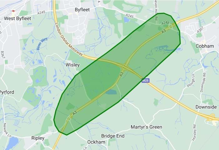
From 9pm Friday 10 May to 6am Monday 13 May, there will be a full closure of the M25 in both directions between Junction 9 (Leatherhead) and Junction 10 (Wisley) to carry out the installation of a bridge and gantry.
Long distance and local diversions will be in place.
Junction 10 is the busiest section of the M25 with over 300,000 vehicles passing through every day.
Our improvements will reduce congestion, create a smoother flow of traffic and provide safer journeys for thousands every day.
Our scheme will see:
- New and safer routes for cyclists, pedestrians and horse-riders
- An additional lane on the A3 in both directions from Ockham and Painshill junctions towards the M25
- A larger roundabout with extra lanes to increase capacity
- Free flow left turns at all four corners of the junction
- Improvements to the A245 Seven Hills junction and Painshill roundabout
- Safer access to Old Lane, Elm Lane, Heyswood campsite and San Domenico
- Improvements to the local environment and wildlife
Our scheme will
- Improve safety and journey times
- Reduce congestion
- Smooth the flow of traffic
- Increased capacity
- Provide better connections
- Improve access for cyclists, pedestrians and horse-riders
- Support local and national economic growth
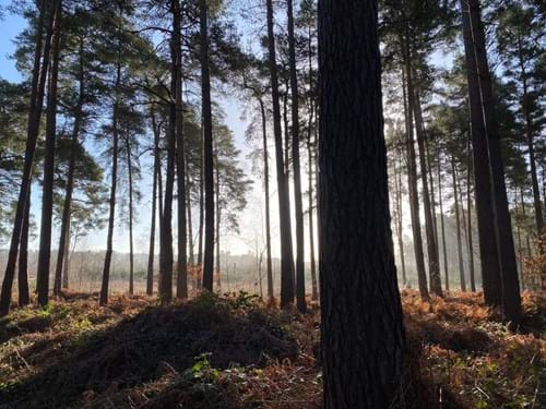
Heathland is one of the UK’s most threatened environments and is a vital habitat for a range of invertebrates, reptiles, and bird species.
We’re restoring large areas of heathland at Wisley and Ockham commons. This long-term process starts with the removal of trees, which might seem concerning at first, but it is the first step to getting it back to its natural state.
Learn more about our tree removal works and why they are needed
Our scheme involves some of the most extensive environmental mitigation ever carried out by National Highways.
More than 16 hectares of land will be used to replace common land and public open space that is needed to improve the junction.
We’re also enhancing other areas of woodland using selective clearance. This involves thinning out conifers to improve the abundance of broadleaf, structurally complex woodland that is more in keeping with the historic landscape and home to a wide range of species.
This work will encourage regrowth and increase the variation of height and age of trees. New areas of native tree and shrub species, which are best suited to the conditions here, will also be planted along and around the roads.
We’ll make sure we leave a lasting environmental legacy that will benefit Ockham and Wisley Common for years to come.
Find out more in our information portal or take a look at our factsheets below.
Factsheets
Our factsheets contain more information about what we’re doing to improve journeys and protect the local environment.
- Heathland restoration and the environment
- A245 improvements
- Water environment
- Pedestrians, cyclists and horse riders – includes closure information
Frequently asked questions
Catch up with past editions of our newsletter or subscribe.
Visit our M25 junction 10/A3 Wisley interchange feedback tool to have your say. The tool includes an interactive map. You can click on a location to make a specific comment, or give us your general feedback.
ECHO is a one-way feedback tool, so if you’d like a response to your feedback you should email the project team at: M25j10@nationalhighways.co.uk
Documents
Consultation documents 2020
Consultation documents 2019
Consultation documents 2018
- Consultation Brochure
- Print Questionnaire
- Preliminary Environmental Information Report - Non-technical Summary
- Preliminary Environmental Information Report - Volume 1 Main Report
- Preliminary Environmental Information Report - Volume 2 Appendices
- Preliminary Environmental Information Report - Volume 3 Figures Part 1
- Preliminary Environmental Information Report - Volume 3 Figures Part 2
- Statutory Notices
- Statement of Community Consultation
- Statement of Community Consultation errata
- M25 junction 10-A3 Wisley North West of junction 10 map
- M25 junction 10-A3 Wisley - Scheme Layout Plan
- M25 Junction 10-A3 Wisley - South-West of junction 10 map
- M25 Junction 10-A3 Wisley - South-East of junction 10 map
- M25 Junction 10-A3 Wisley - Scheme Overview
- Targeted non-statutory consultation brochure
Consultation documents 2017
The Development Consent Order (DCO) process was established by the Planning Act 2008 and is used for certain large and complex schemes that have been designated as a Nationally Significant Infrastructure Project (NSIP) by the Government.
The Secretary of State for Transport granted the Development Consent Order (DCO) for the M25 junction 10/A3 Wisley interchange improvements on 12 May 2022.
Links to key DCO documentation can be found below:
- Examining Authority’s report and recommendations to the Secretary of State for Transport
- Secretary of State for Transport’s decision letter and statement of reasons
- Development Consent Order as made by the Secretary of State for Transport
You can view our full Development Consent Order application on the Planning Inspectorate website.
Current scheme plans and documents are listed at Article 45 in Schedule 11.
Development Consent Order – Requirements Register
Requirements are planning conditions included in the DCO that relate to all or part of the works. They each require documents to be prepared, consulted upon by defined organisations and submitted to the Secretary of State for approval. These processes are referred to here and in the DCO as “discharging” the requirements.
This Requirements Register is a live document and will be updated as the process to discharge the requirements progresses.
The latest version will always be published below:
View the Requirements Register.
This register will be maintained for three years following completion of the project. The register sets out:
- each requirement
- whether the requirement needs approval by the Secretary of State (or other duty holder)
- whether any approval has been applied for or given
Requirements documents
- Requirement 3 – Construction environmental management plan
- Requirement 4 – Traffic management during construction
- Requirement 6 – Landscaping
- Requirement 7 – Design, layout and implementation of Replacement Land
- Requirement 8 – Thames Basin Heaths Special Protection Area (SPA) Compensatory Habitat Creation and Enhancement Areas
- Requirement 9 – Cockcrow Green Bridge
- Requirement 10 – Bolder Mere
- Requirement 12 – Stratford Brook
- Requirement 13 – Department for Transport Sign Off
- Requirement 13 – Ground Investigation Report
- Requirement 13 – Ground Investigation Report - Addendum
- Requirement 13 – Piling Risk Assessment
- Requirement 14 – Archaeology
General Vesting Declarations 1
General Vesting Declarations 1 (scan copy with seal and signatures)
General Vesting Declarations 2
General Vesting Declarations 2 (scan copy with seal and signatures)
General Vesting Declarations 3
General Vesting Declarations 3 (scan copy with seal and signatures)
General Vesting Declarations 4
General Vesting Declarations 4 (scan copy with seal and signatures)
General Vesting Declarations 5
General Vesting Declarations 5 (scan copy with seal and signatures)
General Vesting Declarations 6
General Vesting Declarations 6 (scan copy with seal and signatures)
General Vesting Declarations 7
General Vesting Declarations 7 (scan copy with seal and signatures)
General Vesting Declarations 8
General Vesting Declarations 8 (scan copy with seal and signatures)
General Vesting Declarations 9
General Vesting Declarations 9 (scan copy with seal and signatures)
General Vesting Declarations 10
General Vesting Declarations 10 (scan copy with seal and signatures)
General Vesting Declarations 11
General Vesting Declarations 11 (scan copy with seal and signatures)
General Vesting Declarations 12
General Vesting Declarations 12 (scan copy with seal and signatures)
General Vesting Declarations 13
General Vesting Declarations 13 (scan copy with seal and signatures)
General Vesting Declarations 14
General Vesting Declarations 14 (scan copy with seal and signatures)
General Vesting Declarations 15
General Vesting Declarations 15 (scan copy with seal and signatures)
General Vesting Declarations 16
General Vesting Declarations 16 (scan copy with seal and signatures)
Common Land Application Notice – Annex A
Wisley & Ockham Common – between RHS Gardens Wisley and Wisley Airfield
Wisley & Ockham Common – northeast of RHS Gardens Wisley
Wisley & Ockham Common – around Ockham Bites Café
Wisley & Ockham Common & Chatley Heath – around Wisley Interchange
Wisley & Ockham Common – southwest of Painshill Park
Wisley & Ockham Common – east of Deers Farm Close
Wisley & Ockham Common – west of Wisley Interchange
Chatley Heath – southeast of Wisley Interchange
Related Road projects
Traffic information
Information about scheduled roadworks and events on our motorways and major roads.X
Manage your cookie preferences to view the content on this page
Sign up for updates!
Keep up to date with what's happening on this scheme by signing up to our updates.
