A303 Sparkford to Ilchester
We’re upgrading a three-mile section of the A303 between Sparkford and Ilchester, to make the road safer and more reliable. The delivery of this scheme is part of a long term aim to create a high-quality dual carriage way link between London and the South East and the South West.
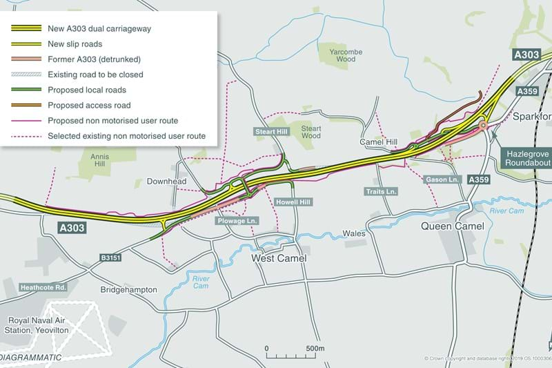
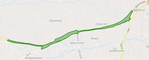
Scheme map
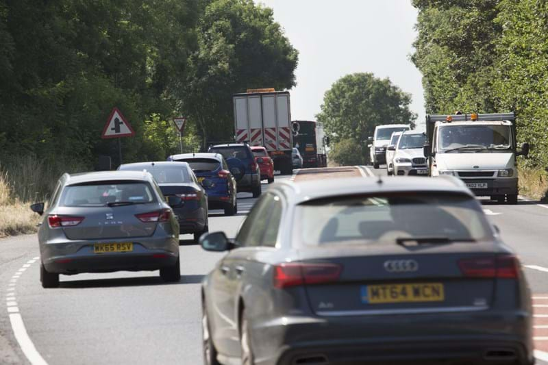
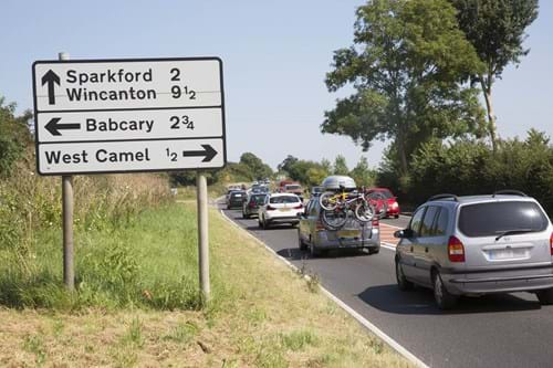
congestion on the A303 in Somerset
View the materials from our engagement van events here
Enter the virtual exhibitionLatest updates
-
15 April 2024
Weekend closure of the A303
What’s happening?
To allow us to carry out the next phase of construction, we need to change the traffic management layout between the Steart Hill junction and Gason Lane, known as the Wales embankment.
We’ll be moving traffic onto a section of the newly built westbound carriageway to allow us a safe area to build the new eastbound carriageway at this location. The traffic management changes are:
- Eastbound traffic will switch onto a single lane of the new westbound carriageway at Steart Hill through to Gason Lane and then back onto the existing A303.
- Westbound traffic will switch from the existing A303 westbound carriageway at Gason Lane and run temporarily on a single lane of the new westbound carriageway, before switching to run temporarily on the eastbound carriageway of the new A303 after Steart Hill.
The changes will happen under a full weekend closure of the A303 between Sparkford and Ilchester. The closure will begin from 9pm on Friday 19 April and we’ll reopen the road at 6am on Monday 22 April. During this closure, we’ll ensure that access will remain for local residents. A signed diversion will be in place for all other traffic.
As part of the weekend closure, westbound A303 traffic will be directed to join the A359 at Sparkford roundabout, travelling to Yeovil to pick up the A37 and rejoining the A303 north of Ilchester. Eastbound A303 traffic will follow the diversion in reverse.
If, due to unforeseen circumstances such as poor weather, we cannot safely carry out the closure on that weekend, we will instead complete the work between 9pm on Friday 26 April until 6am Monday 29 April.
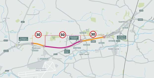
Speed limits through the scheme
These speed limits are in place for the safety of the travelling public and the workforce. The speed limits are influenced by the volume of traffic, junctions, the width of the road and its alignment. Locations where the layout requires traffic to crosses between the existing and new carriageway will have a lower speed limit. The map below outlines where the speed limits change from 30mph to 50mph. Each speed limit will be clearly signed.
-
09 January 2024
Exciting news on the A303 Sparkford to Ilchester scheme
Later this month, we’ll be reaching the next milestone on the A303 Sparkford to Ilchester scheme as we open up a new section of the eastbound carriageway.
On Saturday, 20 January 2024, people travelling east and westbound on the A303 between just east of Podimore roundabout and Steart Hill, will be using the new eastbound carriageway of the A303. The traffic switch is to allow National Highways to carry out the next stage of essential work. This will be after a full closure of the A303 between the Podimore and Sparkford roundabouts from 9pm on Friday 19 January to 6am on Saturday 20 January.
The changes that you’ll see and experience are:
- Eastbound traffic on the A303 will travel from Podimore roundabout and follow traffic management to take them on to the new eastbound carriageway of the A303;
- Westbound traffic on the A303 will switch from the westbound carriageway at Steart Hill and will run temporarily on the new eastbound carriageway of the A303;
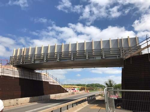
- Local traffic will have different entry and exit points to the A303. The newly built Steart Hill overbridge will be open, connecting the community of Downhead to villages south of the A303;
- There will no longer be access on to or off of the A303 from Steart Hill.
We understand roadworks and changes in road layout can be frustrating, so we’ve communicated the traffic switch well in advance to local communities and residents that are most impacted. We’re making sure that access is maintained for residents and businesses, and we’ll be keeping people fully informed as we continue to progress with the scheme.
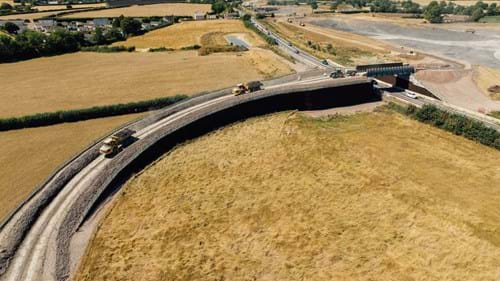
The map below shows what the layout will look like once the switchover is complete. This is the first major switchover for the scheme and as we progress, we’ll keep you updated on when the next one is, so watch this space!
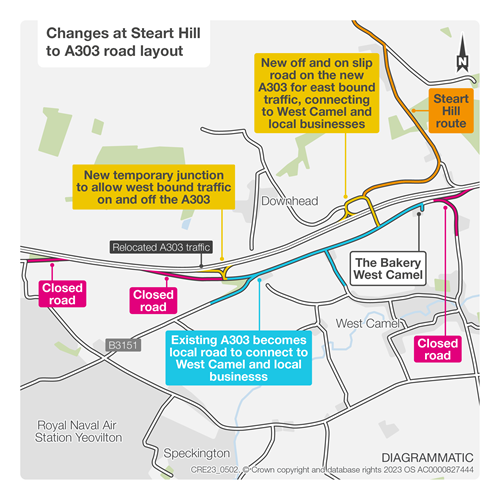
Infographic map: shows what the new layout of the A303 will look like once the traffic switchover is completed.
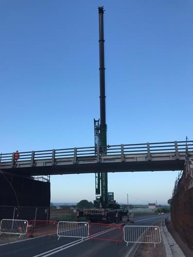
Photo: The new Steart Hill overbridge on the A303 Sparkford to Ilchester scheme
-
11 October 2023
A303 scheme taking shape, two years on
It’s two years on since we started work on the A303 Sparkford to Ilchester scheme and things are really starting to take shape – don’t take our word for it, look at the aerial photos below!
We’ve already hit several milestones throughout the build and the coming months will involve finishing off the new road and linking it in with the existing A303 as it nears completion next year.
Some key achievements over the last two years include:
- Creating five new attenuation ponds to help with drainage on the scheme
- Installing the Steart Hill and Hazlegrove bridge decks – weighing a combined 1,673 tonnes – the same as 137 double decker busses
- Laying 12.5km/over 7.5 miles of drainage piping to date
- Installing the Hazlegrove underpass, designed to connect the communities of Camel Hill with Sparkford and Queen Camel
- Installing more than 300 bird, bat, dormouse and owl boxes, to support wildlife relocation during the construction phase
- Completing 10 archaeological digs.
These achievements have come despite some challenges along the way. These include the wettest July on record which caused widespread flooding in the area and long periods of bad weather in November and March. We’ve done our best to work around these challenges and we’ve been making steady progress and the road has started to take shape.
Unfortunately, despite the progress we’ve made, these challenges have affected our open for traffic date. Although initially due to open in March 2024, that will now be moving to Winter 2024/2025. We’re sorry for the delay but can assure you we are working hard to open the road as quickly as possible and as soon as it’s safe to do so.
We’ll be sure to keep you updated with progress on the scheme and will continue to share updates and images as we progress. If you have any queries or concerns about the scheme, please don’t hesitate to contact us on A303SparkfordtoIlchesterDualling@nationalhighways.co.uk
-
19 June 2023
New traffic management in place
For the past 18 months, our work has mainly been focussed on the – Steart Hill overbridge and Hazlegrove underpass. We’ve also been preparing the surrounding areas ready for the new road. This has meant there hasn’t really been any traffic management in place on the A303 as we’ve carried out the work away from the road.
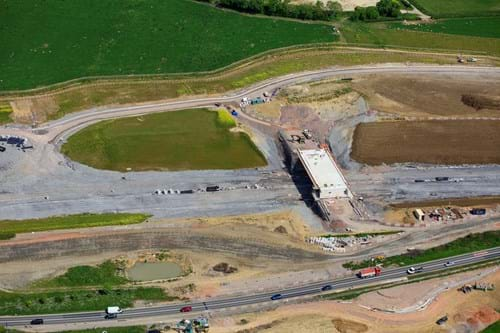
We’ve now reached the stage of the project where you’ll start to see a lot of changes as you travel through the scheme. The aerial shot below shows the progress at Steart Hill overbridge that will connect Downhead to West Camel.
As the new road starts to take shape, we’ll be switching over the traffic so we can work safely on certain sections of the road. The first switch – at the Podimore end of the scheme – will be in place for the next few months with eastbound traffic travelling in a single lane on the westbound carriageway for a short distance from just after Higher Farm Lane to just before the B3151 to Yeovilton (off the Westbound carriageway). For safety, we’ve reduced the speed limit for this section to 30mph. We’ve also closed the westbound slip road to Podimore from the A303. This should help with the traffic cutting through the village of Podimore at busy times.
We’ll continue to keep you updated with progress on the scheme and will let you know in advance of the next traffic switch at Steart Hill. If you’d like further information on the scheme, you can contact us at or call 0300 123 5000
-
02 May 2023
Next phase of works will start this month
From the end of May, we'll be altering the way traffic flows along the A303 between Sparkford and Ilchester - so you might notice some changes as you drive through.
In the first phase of works, we'll be putting a section of Eastbound traffic onto a contraflow on the Westbound carriageway, from just after Higher Farm Lane to just before the B3151 to Yeovilton (off the Westbound carriageway).
You will see traffic management on the road from 9 May, and the new speed limit will be in place from 30 May.
There will be more traffic switches throughout 2023 and into 2024 - we'll keep you up to date as they progress.
Hannah Sanderson, Programme Manager for National Highways, said: “To complete this work safely, we need to introduce some traffic management onto the road and 30mph limits will be required in sections where traffic is crossing over from one side to the other.
“This is being done for the safety of road users and for the safety of our construction team who'll be working closely to the road.
“Our primary goal is to keep all traffic moving, while maintaining the safety of all those using or working alongside the road. We'd like to thank everyone for their patience and understanding.”
“We have analysed traffic flows carefully to check there is no significant risk of disruption and will be keeping everyone fully informed via signing and the media.
“We would ask that drivers plan their journeys and follow signing carefully to avoid being delayed more than necessary and we would like to apologise for any inconvenience caused during these essential works.”
-
14 March 2023
Engagement events: come and meet us
Got questions about the A303 Sparkford to Ilchester scheme and what it means for you, your business or your community?
Our project team will be out and about at a couple of locations close to the scheme over four days at the end of the month.
Come and meet us to talk about the scheme:
- Tuesday, 28 March – Haynes Motor Museum (Sparkford, Yeovil BA22 7LH) 12pm-4pm
- Wednesday, 29 March – Teals Farm Shop (1 Orchard Lane, South Cadbury, Yeovil BA22 7FS) 9am-5pm
- Thursday, 30 March – Teals Farm Shop (1 Orchard Lane, South Cadbury, Yeovil BA22 7FS) 9am-5pm
- Friday, 31 March – Haynes Motor Museum (Sparkford, Yeovil BA22 7LH) 9am-1pm
Steffan Jones, National Highways Project Manager for the A303 Sparkford to Ilchester scheme, said: “The scheme is progressing well, we’re communicating updates and changes as we move forward, but it’s important to engage with local communities and to get any feedback.
“People can put any questions they want to us and we welcome the chance to engage with those directly impacted by the work and anyone interested in the scheme.”
-
25 January 2023
New year, new bridge beams
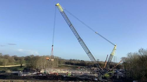
As we move further into 2023, the A303 Sparkford to Ilchester scheme has passed another milestone, as the bridge beams for the Hazlegrove underpass were lifted into place.
A total of 14 beams were lifted in by an 800 tonne crane, supplied by Ainscough, over 8 days. Originally, the work was planned for 2 days - but the windy and rainy conditions held work up; the team worked well to install the beams given the conditions.
The team had used 4-D modelling to build the structure virtually and anticipate any unforeseen problems well before it was built. This way of working meant everyone had some input into the way the structure was built, which in turn helped us save time and plan more efficiently.
The Hazlegrove underpass is one of two main structures on the scheme – alongside the Steart Hill bridge, the underpass will connect local traffic to both sides of the scheme.
Elsewhere on site, we’re now planning for the next stages of scheme, including changes to how the traffic will move along the A303. This won’t start happening until the spring - and we’ll make sure you’re given plenty of notice!
-
08 November 2022
Weekend closure: temporary bridge at Steart Hill being removed
In May, we installed a temporary bridge to move earth from one side of the site to the other without having to use the main A303. Since then we’re moved 900,000 tonnes of earth across it, and now we’re ready to take it down.
Now we’ll be removing it this weekend. So the A303 will be closed between Hazlegrove and Podimore roundabouts from 10pm on Friday, 11 November, to 5am on Monday, 14 November.
There’ll be a clearly signed diversion route via the A359 and the A37.
The removal of the temporary bridge marks a significant milestone for this major scheme, with the major earthworks now completed with minimal disruption.
We will ensure motorists are fully informed of diversions and suggested routes via signing and media. We advise drivers to plan ahead and allow extra time for their journeys over the weekend.
Drivers can obtain up-to-the-minute travel information on local radio the @HighwaysSWEST Twitter feed, by phoning the National Highways Information Line on 0300 123 5000 or by accessing the website: www.trafficengland.com
-
11 October 2022
Temporary bridge removal: coming soon
Next month, we will be removing the temporary bridge on the A303. We've now completed most of the earth moving we needed the bridge for.
The bridge was installed back in May this year to allow us to transport earth from one side of the site to the other. It meant that there was less impact on people using the road - the construction traffic transporting earth didn’t need to go onto the A303. Thanks to a dry summer, we’re now ready to take it down, having moved more than 900,000 tonnes of earth.
To remove the bridge, we will need to close the A303 between Hazlegrove roundabout and Podimore roundabout for a weekend, from 10pm on Friday, 11 November, to 5am on Monday, 14 November.
During this weekend closure, clearly signed diversions will be in place via the A359 and the A37.
When the work takes place in November, our advice to people using the road is to plan ahead as the diversion will add time to journeys. Before you travel, you can obtain up-to-the-minute travel information on the @HighwaysSWEST Twitter feed, by phoning the National Highways Information Line on 0300 123 5000 or by accessing the website: www.trafficengland.com
-
08 September 2022
Moving mountains: a site update
We’ve been on site on the A303 between Sparkford and Ilchester for over a year now – and if you’ve driven past the site, you’ll have seen a lot of changes.
The main work you’ll be able to see is trucks moving earth between the two sides of the A303. We’re now working opposite the Steart Hill junction at the Wales embankment, moving soil to get that part of the site to the right level for the new road. Since starting the scheme last year, we've now completed more than 60 per cent of the earthworks, moving around 900,000 tonnes of earth – that’s the same weight as 72,000 double decker buses! This means we’ll be able to remove the temporary bridge later this year – more news to follow on this next month.
We haven’t just been moving soil, though. We’re also working on two of the main structures on site – the Steart Hill bridge and the Hazlegrove underpass. In the next couple of weeks, we’ll be installing the bridge beams onto Steart Hill bridge, which will take local traffic over the new dualled A303. These were delivered last week and we’re now ready for them to be seated in place in the next couple of weeks. Once these beams are in place, the next stage, in October, will be to pour the concrete to form the bridge deck.
As you can see, it’s been a busy year for us on site and we continue to make good progress towards our ‘open for traffic’ date in Spring 2024. If you have any questions about what is happening on site or would like more information, please drop us a line at A303SparkfordtoIlchesterDualling@nationalhighways.co.uk

-
26 August 2022
A303 Podimore to Sparkford essential maintenance works - Tuesday 30 August to Saturday 3 September 2022
National Highways will soon be doing a short scheme of maintenance work on the A303 between Podimore and Sparkford. This isn’t part of the major upgrade scheme – it’s just a small maintenance project to do very minor works, for example filling potholes.
To do this work we’ll need to fully close the A303 between Podimore roundabout and Hazelgrove roundabout. The closures will be limited to overnight between the hours of 9pm and 4am, starting on the evening of Tuesday 30 August and finishing on the morning of Saturday 3 September.
We’re doing this work during the night to minimise disruption, as there are fewer vehicles on the road at night. The A303 will be open as usual during the day. There will be a fully signed diversion route in place during the full overnight closures, but we advise to allow extra time for your journey.
We’ll make every effort to minimise the impact on the local community and travelling public. We always aim to work to the programme, but unforeseen circumstances or adverse weather conditions may mean changes. Please monitor www.trafficengland.com to stay up to date. If you would like further information about this work, please contact the National Highways Customer Contact Centre on 0300 123 5000 open 24/7, who will direct your enquiry to the most appropriate person, or email: info@nationalhighways.co.uk
-
16 May 2022
Bridge lift completed early
On Saturday 13 May, the A303 Sparkford to Ilchester scheme hit a milestone with style as a temporary bridge was installed 35 hours ahead of schedule!
In the early hours of Saturday morning, a 200-tonne crane lifted the new bridge into place. This new temporary bridge is a vital part of the scheme – it will keep construction off the main road, reducing the impact of the scheme on road users and residents.
The project team had arranged to close the A303 in both directions – between Hazlegrove roundabout and Podimore roundabout – for a whole weekend. But thanks to a fantastic team effort, the road was back open Saturday at 5:30pm, rather than Monday morning. It was the first time the scheme needed a full closure and thanks to sdthe hard work of the project team and its contractors, the bridge was installed without issues and well ahead of time.
As part of the preparation work, more than 2,500 letters were sent to residents along the diversion route, as well as lots of engagement with the local residents, businesses and parish councils to help minimise the impact of the closure.
Elliot Hayes, National Highways’ Senior Project Manager for the scheme, said: ‘As the first total closure of the scheme, we were keen for the bridge installation to go smoothly. We're really glad it all went well and we could reopen the road early.
This bridge connects both sides of the scheme, which is vital for the progress of the earth moving operation. Now that this is complete, we’ll really be able to ramp up the work on the south side of the scheme.'
-
27 April 2022
Road closure planned for bridge lift
As work on the A303 Sparkford to Ilchester scheme progresses, we are getting ready to install a new temporary bridge. Work has been progressing well on site – over the last couple of months we’ve been doing fencing work, lots of site clearance and installing bird, bat and dormouse boxes. Installing the bridge is the next big milestone and will be a significant new addition to the scheme landscape.
The bridge, which will be in place at Steart Hill on the A303, will be used to transport earth from one side of the site to the other. This new bridge will mean we’ll have less impact on people using the road - the construction traffic transporting earth from one side of the site to the other won’t need to use the A303.
To install the bridge – which is only temporary and will be removed before the end of the scheme – we will need to close the A303 between Hazelgrove roundabout and Podimore roundabout for a weekend, from 10pm on Friday, 13 May, to 5am on Monday, 16 May. During the weekend closures, clearly signed diversions will be in place via the A359 and the A37.
When the work takes place in May, our advice to people using the road is to plan ahead as the diversion will add time to journeys. Before you travel, you can obtain up-to-the-minute travel information on the @HighwaysSWEST Twitter feed, by phoning the National Highways Information Line on 0300 123 5000 or by accessing the website: www.trafficengland.com
-
25 April 2022
Road closure planned for bridge lift
As work on the A303 Sparkford to Ilchester scheme progresses, we are getting ready to install a new temporary bridge. Work has been progressing well on site – over the last couple of months we’ve been doing fencing work, lots of site clearance and installing bird, bat and dormouse boxes. Installing the bridge is the next big milestone and will be a significant new addition to the scheme landscape.
The bridge, which will be in place at Steart Hill on the A303, will be used to transport earth from one side of the site to the other. This new bridge will mean we’ll have less impact on the travelling public - the construction traffic transporting earth from one side of the site to the other won’t need to use the A303. It'll only be temporary and will be removed before the scheme finishes.
To install the temporary bridge, we will need to close the A303 between Hazelgrove roundabout and Podimore roundabout for a weekend - from 10pm on Friday 13 May to 5am on Monday 16 May. During the weekend closures, clearly signed diversions will be in place via the A359 and the A37.
When the work takes place in May, our advice to people using the road is to plan ahead as the diversion will add time to journeys. Before you travel, you can obtain up-to-the-minute travel information on the @HighwaysSWEST Twitter feed, by phoning the National Highways Information Line on 0300 123 5000 or by accessing the website: www.trafficengland.com
-
16 February 2022
Back in full swing - and a bridge on the way
After a wet start to the year, the Sparkford to Ilchester dualling scheme is back in full swing, with the main focus on getting the abutments ready for the temporary bridge at Steart Hill. Abutments are the supporting structures either side of the span of the bridge.
We’ll be installing the temporary bridge in April, so we can use it to transport thousands of tonnes of earth from the site near Steart Hill to the site at Hazlegrove. The vehicles used to transport this earth aren’t allowed on the main A303, so the bridge connecting the two sections will be a vital part of the project.
Elsewhere, we’re carrying out archaeological surveys across the site to check for anything of significance and the environment team will be installing over 400 bird, bat and dormouse boxes in the coming weeks. These will provide nesting and roosting opportunities for birds, bats and dormice, where we’re removing sections of habitat that they would normally use. Once the road is built, we’ll recreate woodland, hedgerow and grassland habitats to provide long term homes for these species.
Over the next few weeks, we’ll be talking more about the environmental work we’re doing, so watch this space!
-
01 November 2021
Progress update November
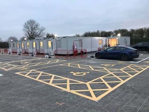
This week the A303 Sparkford to Ilchester project team moved into their new site offices, located at the Royal Naval Air Station, Yeovilton.
These offices will accommodate the project support team with space for up to 36 people, with two large meeting rooms and a ‘quiet room’. The new space provides a fresh and airy working environment and there are good parking facilities for the team which will minimise traffic movements near to the local community.
Work on the construction of the dual carriageway is progressing well. The team have been making the most of the fine dry weather throughout November, enabling the earthworks and fencing to progress at a pace.
At the eastern end of the scheme, towards Hazlegrove, the removal of topsoil continues under the watchful eye of archaeologists. They will be working on the scheme into 2022 and as of yet, there have been no significant finds of interest.
-
08 October 2021
Start of work
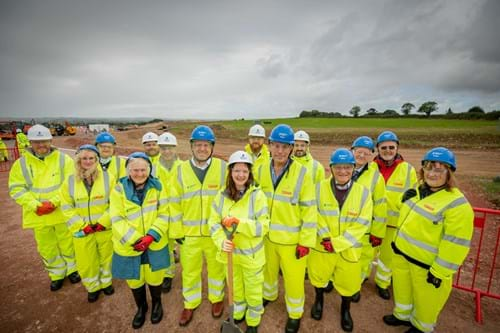
On Friday 1 October we marked the start of our work on the A303 Sparkford to Ilchester dual carriageway project. This £135 million road scheme will provide a major boost to the South West’s economy, whilst improving local journeys and making roads safer.
Members of Parliament, and council members from across the region joined us for our first event on site. We visited the construction site, alongside Steart Hill, where teams are preparing the area for the first of our three office locations.
Our current work is all about preparing the ground for construction. We're also building some temporary roads, which will carry the materials and site vehicles across the scheme, to reduce the impact on local roads and villages.
Our main construction will get under way in 2022 which means we'll only have minimal roadworks on the road until early next year.
You can find out more about the project by visiting our virtual exhibition.
We value your feedback
Visit our A303 Sparkford to Ilchester feedback tool to have your say. The tool includes an interactive map. You can click on a location to make a specific comment or give us your general feedback.
If you'd like a direct response to your feedback please email us at: A303SparkfordtoIlchesterDualling@highwaysengland.co.uk
-
29 January 2021
Planning permission granted
On 29 January the Secretary of State’s granted the Development Consent Order to upgrade the A303 between Sparkford and Ilchester. We’re thrilled at this decision as this scheme will support a growth in jobs and housing by creating a free-flowing and reliable connection between the south east and south west.
You can view our application and the decision on the Planning Inspectorates webpage.
We will now finalise the detailed design with our contractors, and currently anticipate starting on site later this year. We’ll provide more detail on next steps shortly.

Project information
Visit our A303 Sparkford to Ilchester feedback tool to have your say. The tool includes an interactive map. You can click on a location to make a specific comment, or give us your general feedback.
ECHO is a one-way feedback tool, so if you’d like a response to your feedback you can email the project team at: A303SparkfordtoIlchesterDualling@highwaysengland.co.uk

You can also find out more about the project and upcoming our closures by visiting our virtual exhibition.
The A303/A358 corridor is a vital connection between the South West and London and the South East.
While much of the corridor is a dual carriageway, there are still over 35 miles of single carriageway. These sections act as congestion bottlenecks, particularly in the summer months and at weekends, causing delays to road users, and they add to an increased risk of accidents.
We're proposing to dual a three-mile single carriageway section between Sparkford and Ilchester. On an average day the road carries 23,500 vehicles, but numbers increase significantly in the summer, particularly at weekends making journeys unreliable and unpredictable. This scheme will reduce congestion, improve journey times and make our network safer for customers.
The new dualled section will start east of Podimore Roundabout and will follow the alignment of the existing A303 to Downhead. Travelling eastwards, it then moves north of the existing A303 single carriageway, allowing the existing road to be kept for use as a local road in this section.
The route then rises up West Camel Hill before crossing over the existing A303 at the junction with Steart Hill/Howell Hill. It then takes a southerly alignment before meeting up with the existing road again to pass between Vale Farm and the MOD signal station at Eyewell/Traits Land.
Finally, the route bypasses the existing Hazlegrove Roundabout to the north through the Registered Park and Garden associated with Hazlegrove House, before tying into the existing A303 Sparkford Bypass.
In delivering the scheme, we’re aiming to:
- improve the capacity of the road to reduce delays and queues that occur during peak hours and at key times of the year i.e. the height of summer.
- support economic growth, facilitating growth in jobs and housing by providing a free-flowing and reliable connection between the South East and the South West
- make the road safer, by providing additional capacity and reducing driver stress. We’ll make routes safer for pedestrians, cyclists, horse riders in the area.
- protect the environment and look for opportunities to improve it, minimising any unnecessary impact of the scheme on the surrounding natural and historic environment and landscape.
- work with local communities to reduce the impact of the road on a sense of community severance, and look for ways to improve local peoples’ quality of life
- make journey times more reliable and resilient, by providing more capacity it will become easier to manage traffic when incidents occur.
Documents
A303 Sparkford March 2024 Newsletter
A303 Sparkford January 2024 Newsletter
A303 Sparkford September 2022 newsletter
A303 Sparkford May 2021 newsletter
A303 Sparkford June 2020 newsletter
A303 Sparkford autumn 2019 newsletter
Regional Designated Funds newsletter - autumn 2019
A303 Sparkford summer 2019 newsletter
A303 Sparkford summer 2018 newsletter
Survey Fact Sheets - Introduction
Survey Fact Sheets - Noise
Survey Fact Sheets - Agriculture, Soils and Land
Survey Fact Sheets - Ecology
Survey Fact Sheets - Air Quality
Survey Fact Sheets - Archaeology
Survey Fact Sheets - Water Ecology
Survey Fact Sheets - Ground conditions (Geotechnical)
Environmental Statement - Non-Technical Summary
Environmental Statement - Addendum
Environmental Statement - Addendum Appendix A Section 1
Environmental Statement - Addendum Appendix A Section 2
Environmental Statement - Addendum Appendix B Section 1
Environmental Statement - Addendum Appendix B Section 2
Environmental Statement - Addendum Appendix B Section 3
Environmental Statement - Addendum Appendix B Section 4
The Development Consent Order (DCO) process was established by the Planning Act 2008 and is used for certain large and complex schemes (including highway improvements) that have been designated as a Nationally Significant Infrastructure Project (NSIP) by the Government.
The Secretary of State for Transport granted the Development Consent Order (DCO) for the A303 Sparkford to Ilchester dualling scheme on 29 January 2021. Links to key DCO documentation can be found below:
- Examining Authority’s report and recommendations to the Secretary of State for Transport
- Secretary of State for Transport’s decision letter and statement of reasons
- Development Consent Order as made by the Secretary of State for Transport
You can view our full Development Consent Order application on the Planning Inspectorate website.
This includes documents identified under Article 43 and Schedule 9 of our Development Consent Order, which have been certified as true copies by the Secretary of State.
Development Consent Order – Requirements Register
Requirements are conditions that have been included in the DCO, which control how the project must be implemented (constructed and maintained). Implementing the DCO in accordance with these conditions involves completing consultation and approval processes that have been defined in the DCO. These processes are referred to here and in the DCO as “discharging” the requirements.
This Requirements Register is a live document and will be updated as the process to discharge the requirements progresses.
The latest version will always be published below:
View the Requirements Register.
This register will be maintained for three years following completion of the project. The register sets out:
- each requirement
- whether the requirement needs approval by the Secretary of State (or other duty holder)
- whether any approval has been applied for or given
General Vesting Declaration documents
A303 Sparkford to Ilchester General Vesting Declaration No.1 Plan (unsigned)
A303 Sparkford to Ilchester General Vesting Declaration No.1 Plan (signed)
A303 Sparkford to Ilchester General Vesting Declaration No.1 (signed)
A303 Sparkford to Ilchester General Vesting Declaration No.1 (unsigned)
A303 Sparkford to Ilchester General Vesting Declaration No.2 Plan (unsigned)
A303 Sparkford to Ilchester General Vesting Declaration No.2 Plan (signed)
A303 Sparkford to Ilchester General Vesting Declaration No.2 (signed)
A303 Sparkford to Ilchester General Vesting Declaration No.2 (unsigned)
A303 Sparkford to Ilchester General Vesting Declaration No.3 Plan (unsigned)
A303 Sparkford to Ilchester General Vesting Declaration No.3 Plan (signed)
A303 Sparkford to Ilchester General Vesting Declaration No.3 (signed)
A303 Sparkford to Ilchester General Vesting Declaration No.3 (unsigned)
A303 Sparkford to Ilchester General Vesting Declaration No.4 (signed)
A303 Sparkford to Ilchester General Vesting Declaration Plan No.4
A303 Sparkford to Ilchester General Vesting Declaration No.5 (signed)
A303 Sparkford to Ilchester General Vesting Declaration Plan No.5
A303 Sparkford to Ilchester General Vesting Declaration No.6 (signed)
A303 Sparkford to Ilchester General Vesting Declaration Plan No.6
A303 Sparkford to Ilchester General Vesting Declaration No.7 (signed)
A303 Sparkford to Ilchester General Vesting Declaration Plan No.7
A303 Sparkford to Ilchester General Vesting Declaration No.8 (signed)
A303 Sparkford to Ilchester General Vesting Declaration Plan No.8
A303 Sparkford to Ilchester General Vesting Declaration No.9 (signed)
A303 Sparkford to Ilchester General Vesting Declaration Plan No.9
A303 Sparkford to Ilchester General Vesting Declaration No.10 (signed)
A303 Sparkford to Ilchester General Vesting Declaration Plan No.10
A303 Sparkford to Ilchester General Vesting Declaration No.11 (signed)
A303 Sparkford to Ilchester General Vesting Declaration Plan No.11
A303 Sparkford to Ilchester General Vesting Declaration No.12 (signed)
A303 Sparkford to Ilchester General Vesting Declaration Plan No.12
A303 Sparkford to Ilchester General Vesting Declaration No.13 (signed)
A303 Sparkford to Ilchester General Vesting Declaration Plan No.13
Related Road projects
Traffic information
Information about scheduled roadworks and events on our motorways and major roads.X
Manage your cookie preferences to view the content on this page
Sign up for updates!
Keep up to date with what's happening on this scheme by signing up to our updates.
